
Have you ever received a marketing email or push notification as you walk by a shop or any business?
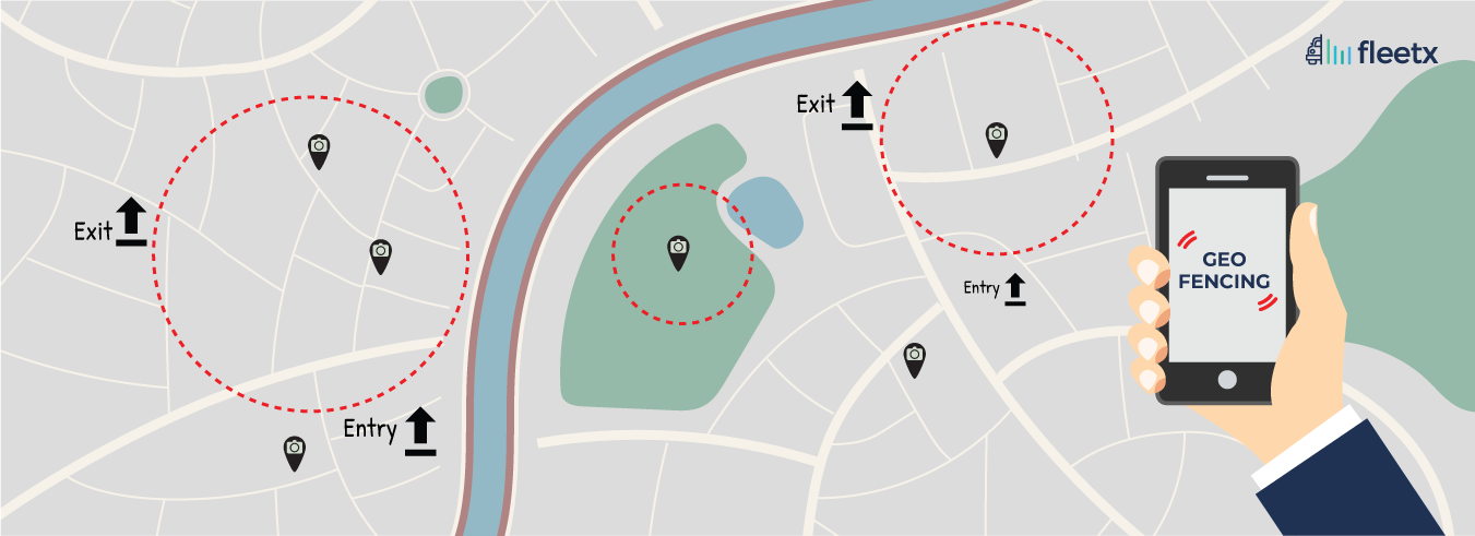
These notifications are based on geofence and triggered when users reach a predetermined boundary. Many companies use this type of notification to send their users information about the active deals available. This technology is called Geofencing, it uses GPS technology to get the location of the users, and whenever users are about to enter or exit these predefined virtual boundaries, it triggers and sends an alert to the users. It is also a marketing tactic used by the company to remind their users about the deal, enabling them to respond quickly.
How Geo-fencing Impact Logistics Companies
The geofence can be easily set up around all of your warehouse addresses and other stop points to increase efficiency for inbound and outbound loads. The main purpose of this is to organize your vehicles in such a manner that they arrive at the dock, and start loading or unloading with less waiting time. With geofencing, the terminals can receive alerts for inbound loads that are approaching and similarly for outbound loads. The ability to view all this information in real-time allows the management team to be more flexible with an improved schedule and planning.
Tracking software can be an excellent investment to improve customer satisfaction levels in your delivery operations. This is because, with a system like that in place, managers can quickly set alerts to notify customers when their packages enter their zone with an estimated time of arrival.
Advantages of Geofencing for logistics companies
Logistics company that uses fleet management software and geofencing technology will have a significant advantage over their competitors. Software and technology offer better real-time transparency and improves the overall operational efficiency of the logistics company. Some of them are highlighted below:
Event-triggered actions
Geofence can help you triggered an event action in your logistics company. This triggered event can be utilized to prepare the team for processing the incoming carriers and shipments. In this way, the time required for the carriers to spend on the dock is reduced, which results in lesser detention time and quicker dispatch.
Improved assets security
Asset management and GPS tracking become even more secure with the help of geofencing. It secures all the static assets with the help of strategic geofencing around the warehouse. Any breach in the area can be instantly detected and diagnosed.
Real-time coordination
When the carrier enters the geofenced area, it can coordinate on a real-time basis to update the onward trip automatically without manual intervention. It will automatically interpret the remaining distance and expected arrival, speed of the carrier and necessary stop points and duration of the trip. And it also automatically updates all the details if the carrier faced an unexpected stoppage during that time.
Improved Planning
Geofencing majorly relies on GPS trackers and the mobile app for the update of carrier real-time movement. This always keeps the operations staff at the forefront with the necessary information for making any changes in the planned trip and helps them to keep on improving the supply chain by making required changes in order to keep the deliveries on time.
In the logistics company, it is important to use the customized solutions as the companies differ from each other vastly in terms of size and scale of operations. Fleetx provides customized fleet management solution for both small and large fleet business to manage their operation more efficiently with geofencing and other smart features.
How to Measure the Success of Geofencing in Logistics Operations
Simply implementing geofencing is not enough. Logistics companies should regularly evaluate whether geofence-based automation is improving operational performance. Monitoring the right KPIs helps fleet managers identify bottlenecks, optimize routes, and maximize returns from their GPS and telematics investments.
Key Performance Metrics to Track
Businesses using geofencing should monitor the following indicators:
- Average vehicle turnaround time: Measures how quickly vehicles complete loading, unloading, and depart from customer or warehouse locations.
- Dock waiting time: Tracks how long trucks remain idle before loading or unloading begins.
- On-time arrival percentage: Evaluates whether vehicles consistently reach destinations within the scheduled time window.
- Route deviation incidents: Identifies unauthorized or inefficient route changes that increase fuel costs and delays.
- Geofence breach alerts: Monitors vehicles entering or exiting restricted areas without authorization.
- Customer notification accuracy: Measures whether automated ETA and arrival alerts accurately reflect vehicle movement.
- Fuel efficiency improvements: Compares fuel consumption before and after implementing geofencing-enabled route monitoring.
Why Continuous Monitoring Matters
Regular analysis of these metrics helps logistics companies:
- Identify recurring operational bottlenecks.
- Reduce detention and idle time.
- Improve dispatch planning.
- Increase fleet utilization.
- Enhance customer satisfaction through accurate delivery updates.
- Make better data-driven decisions using telematics insights.
Organizations that combine geofencing with continuous performance monitoring are better positioned to improve operational efficiency while lowering transportation costs over time.
Geofencing Use Cases Across Different Logistics Industries
Although geofencing is commonly associated with vehicle tracking, its applications extend across multiple industries where real-time location intelligence improves operational visibility and compliance.
Industry-Specific Applications
E-commerce and Last-Mile Delivery
- Automatically notify customers when delivery vehicles enter their locality.
- Monitor delivery completion without manual confirmation.
- Optimize delivery scheduling based on real-time driver movement.
Manufacturing
- Track inbound raw material shipments.
- Monitor dispatch timings for finished goods.
- Improve coordination between warehouses and production facilities.
Cold Chain Logistics
- Generate alerts if temperature-sensitive shipments deviate from approved routes.
- Track dwell time at warehouses and distribution hubs.
- Improve compliance for pharmaceutical and food transportation.
Construction and Mining
- Monitor movement of heavy equipment across project sites.
- Prevent unauthorized equipment usage outside designated work zones.
- Improve asset utilization across multiple locations.
FMCG Distribution
- Track distributor deliveries in real time.
- Reduce unloading delays at retail locations.
- Improve delivery consistency across high-volume routes.
Business Benefits Across Industries
Regardless of the industry, geofencing helps organizations:
- Improve supply chain visibility.
- Reduce manual tracking efforts.
- Increase operational transparency.
- Strengthen asset security.
- Enable proactive decision-making through automated alerts.
- Improve customer communication using real-time location updates.
These use cases demonstrate that geofencing is not limited to fleet tracking but serves as a broader operational intelligence tool for modern logistics networks.
How does Traditional GPS Tracking and Geofencing Technology Differ
While both GPS tracking and geofencing rely on location data, they solve different operational challenges. Understanding their differences helps logistics businesses choose the right technology strategy.
| Feature | Traditional GPS Tracking | Geofencing Technology |
|---|---|---|
| Primary purpose | Tracks live vehicle location | Automates actions based on virtual geographic boundaries |
| Real-time alerts | Limited to manual monitoring | Automatic entry, exit, dwell-time, and breach notifications |
| Warehouse automation | Minimal | Automatically triggers loading and unloading workflows |
| Customer notifications | Usually manual | Automated ETA and arrival alerts |
| Route compliance | Requires manual review | Instant alerts for route deviations |
| Asset security | Tracks asset location | Detects unauthorized movement from designated zones |
| Operational efficiency | Provides visibility | Improves visibility while automating operational processes |
| Human intervention | Higher | Lower through automated event triggers |
| Best suited for | Basic fleet tracking | Smart fleet management, logistics automation, and supply chain optimization |
Which Solution Delivers Greater Value?
GPS tracking provides the foundation for fleet visibility, while geofencing transforms that location data into automated operational actions. Businesses looking to reduce manual intervention, improve customer communication, strengthen security, and streamline logistics operations achieve the greatest benefits when geofencing is integrated with GPS tracking and a fleet management platform rather than using GPS tracking alone.
Frequently Asked Questions
What is geofencing in a Transport Management System (TMS)?
Geofencing in a Transport Management System (TMS) is a GPS- and location-based technology that creates virtual boundaries around real-world locations such as warehouses, factories, customer delivery points, toll plazas, distribution hubs, ports, or restricted zones. Whenever a vehicle enters, exits, or remains inside these predefined boundaries, the system automatically performs specific actions like generating alerts, recording arrival or departure times, updating ETAs, triggering proof of delivery workflows, or notifying fleet managers.
Unlike traditional GPS tracking, which simply displays where a vehicle is located, geofencing adds automation and operational intelligence to logistics. Instead of manually monitoring every truck, businesses receive real-time updates whenever important transport events occur.
For logistics companies across India—including Delhi, Delhi NCR, Gurgaon, Mumbai, Bengaluru, and Pune—geofencing helps improve fleet visibility while reducing manual coordination. It is especially valuable for businesses handling FMCG distribution, manufacturing, e-commerce, pharmaceuticals, retail deliveries, and cold-chain transportation.
Some common applications include:
- Automatically logging warehouse arrival and departure times.
- Receiving instant alerts for route deviations.
- Monitoring unauthorized vehicle stoppages.
- Improving ETA accuracy through automated notifications.
- Enhancing customer communication with real-time delivery updates.
- Supporting SLA compliance and operational reporting.
Modern transport businesses increasingly consider geofencing an essential capability within the best Transport Management Systems because it transforms raw GPS data into actionable operational insights. This makes geofencing one of the most valuable technologies for improving efficiency, reducing delays, and strengthening supply chain visibility.
How does geofencing help reduce delivery delays and improve fleet efficiency?
Delivery delays rarely result from one major incident. More often, they occur because of multiple small issues such as unauthorized stops, route deviations, dock congestion, traffic bottlenecks, inaccurate ETAs, and delayed dispatches. Geofencing helps identify these problems in real time before they become major operational disruptions.
When a vehicle crosses a predefined geofence, the Transport Management System immediately records operational events and can automatically notify dispatch teams, customers, or warehouse managers. Instead of relying on manual phone calls or driver updates, fleet managers receive accurate location-based information instantly.
Businesses operating in Delhi NCR, Gurgaon, Mumbai, Bengaluru, Pune, and other major logistics hubs benefit significantly because urban congestion makes delivery planning more complex.
Key operational advantages include:
- Instant alerts for unauthorized stoppages.
- Automatic ETA recalculations after route deviations.
- Real-time warehouse entry and exit tracking.
- Better planning of loading and unloading operations.
- Reduced manual follow-ups between drivers and dispatch teams.
- Improved On-Time In-Full (OTIF) performance.
- Greater customer satisfaction through proactive delivery updates.
Combined with AI-powered route optimization and GPS tracking, geofencing enables transport companies to proactively manage operations instead of reacting after delays have already occurred. This improves fleet productivity while reducing operational costs and strengthening overall supply chain performance.
What is the difference between GPS tracking and geofencing in logistics?
Although GPS tracking and geofencing are closely related technologies, they serve different purposes within logistics and fleet management. GPS tracking primarily focuses on displaying the real-time location of vehicles, whereas geofencing uses GPS data to automate operational workflows whenever vehicles enter or leave predefined locations.
Think of GPS tracking as answering the question "Where is my vehicle?" while geofencing answers "What should happen because my vehicle has reached this location?"
For transport operators across India, especially those managing large fleets in Delhi, Mumbai, Bengaluru, Gurgaon, Pune, and Delhi NCR, geofencing provides far greater operational control than standalone GPS tracking.
Major differences include:
- GPS tracking provides continuous vehicle location visibility.
- Geofencing automatically triggers alerts and workflows.
- GPS requires more manual monitoring by dispatch teams.
- Geofencing automates arrival, departure, and dwell-time recording.
- GPS helps locate vehicles.
- Geofencing improves compliance with routes and delivery schedules.
- GPS supports visibility, whereas geofencing supports operational automation.
The best transport management software combines GPS tracking, geofencing, AI-driven analytics, and automated notifications into a single platform. Together, these technologies help logistics businesses improve delivery performance, reduce fuel waste, strengthen security, and make more informed operational decisions.
What is the cost of implementing geofencing in a Transport Management System in India?
The cost of implementing geofencing in a Transport Management System (TMS) depends on several factors, including fleet size, GPS hardware, software capabilities, number of geofences required, integrations, AI features, reporting requirements, and deployment model. Most modern cloud-based TMS providers include geofencing as part of their subscription rather than charging separately, making it more affordable for businesses of all sizes.
For companies operating across Delhi, Delhi NCR, Gurgaon, Mumbai, Bengaluru, and Pune, implementation costs also vary depending on the number of operational locations such as warehouses, manufacturing plants, customer sites, hubs, and distribution centers that need virtual boundaries.
As a general estimate, businesses may encounter:
- Small fleets (10–50 vehicles): approximately ₹1,000–₹3,000 per vehicle per month.
- Medium fleets (50–300 vehicles): customized enterprise pricing with additional automation features.
- Large enterprises: pricing is usually quotation-based depending on integrations, analytics, AI capabilities, and deployment scale.
Beyond software pricing, organizations should also consider implementation services, GPS device installation (if required), employee training, API integrations with ERP or warehouse systems, and ongoing support.
Rather than selecting the lowest-priced solution, businesses should evaluate the overall return on investment. A well-implemented geofencing solution can significantly reduce fuel costs, minimize unauthorized stoppages, improve delivery accuracy, lower manual coordination efforts, and increase vehicle utilization. For many logistics companies in India, these operational savings often outweigh the initial investment within a relatively short period, making geofencing a cost-effective technology for long-term fleet optimization.
Which are the best Transport Management Systems with geofencing capabilities in India?
The best Transport Management System (TMS) with geofencing capabilities is one that combines GPS tracking, automated alerts, AI-driven analytics, route optimization, ETA prediction, trip management, proof of delivery, and reporting within a single platform. While geofencing is now available in many logistics solutions, businesses should choose software that integrates this feature into everyday transport operations rather than offering it as a standalone tool.
For companies operating in India—particularly in Delhi NCR, Gurgaon, Mumbai, Bengaluru, Pune, and other major logistics corridors—the ideal TMS should support high shipment volumes, multiple warehouses, and real-time operational visibility.
When evaluating the best transport management software, look for features such as:
- Automated geofence creation around warehouses and delivery locations.
- Real-time route deviation alerts.
- AI-powered ETA prediction and route optimization.
- Electronic Proof of Delivery (ePOD).
- Driver behavior monitoring.
- Fleet analytics dashboards.
- ERP and Warehouse Management System integration.
- Scalability for growing fleets.
Rather than choosing software solely based on popularity, businesses should compare implementation support, customer service, reporting capabilities, customization options, security, and long-term scalability. The top geofencing-enabled TMS platforms help organizations reduce delays, improve customer satisfaction, strengthen compliance, and make better operational decisions through intelligent automation instead of relying on manual monitoring.
How do logistics companies in Delhi NCR and Gurgaon use geofencing for better fleet management?
Delhi NCR and Gurgaon are among India's busiest logistics regions, serving manufacturing clusters, e-commerce fulfillment centers, industrial parks, retail distribution hubs, and corporate supply chains. Heavy traffic, multiple delivery locations, strict customer SLAs, and complex transportation networks make geofencing an essential operational tool for logistics companies operating in these areas.
Transport businesses use geofencing to automate workflows instead of manually tracking every vehicle. Virtual boundaries are created around warehouses, customer locations, toll points, industrial zones, ports, and distribution centers. Whenever vehicles enter or leave these locations, the Transport Management System automatically records operational events and sends real-time notifications.
Common use cases include:
- Tracking warehouse arrival and departure times automatically.
- Monitoring vehicle dwell time at customer locations.
- Receiving alerts for unauthorized route deviations.
- Reducing delays caused by traffic congestion.
- Improving delivery planning using live ETA updates.
- Supporting last-mile delivery operations across urban areas.
- Enhancing communication between dispatch teams, customers, and drivers.
With increasing freight movement across Delhi, Noida, Faridabad, Ghaziabad, Manesar, and Gurgaon, geofencing enables transport companies to improve fleet utilization while reducing manual intervention. Businesses also benefit from better compliance reporting, improved OTIF performance, enhanced customer experience, and more accurate operational data for long-term logistics planning.
How do logistics companies in Mumbai, Bengaluru, and Pune benefit from geofencing technology?
Mumbai, Bengaluru, and Pune are among India's fastest-growing logistics and manufacturing hubs, each presenting unique transportation challenges. Mumbai handles high freight movement through ports and urban distribution networks, Bengaluru supports technology, e-commerce, and electronics manufacturing, while Pune is home to major automotive, engineering, and industrial supply chains. In these cities, traffic congestion, multiple delivery points, unpredictable travel times, and strict customer delivery commitments make geofencing an essential capability within a modern Transport Management System.
Geofencing enables transport companies to automate operational workflows instead of depending on manual coordination. Whenever a vehicle reaches a warehouse, customer location, industrial park, or distribution centre, the system automatically records arrival and departure times, updates ETAs, and alerts stakeholders about delays or route deviations.
Major benefits include:
- Real-time monitoring of high-value shipments.
- Automatic alerts for unauthorized stoppages.
- Improved coordination between warehouses and transport teams.
- Reduced vehicle idle time at customer locations.
- More accurate delivery scheduling.
- Enhanced fleet security for long-distance transportation.
- Improved customer communication through automated notifications.
Businesses operating across Mumbai, Bengaluru, Pune, and other metropolitan regions also gain better visibility into fleet productivity and operational efficiency. By integrating geofencing with AI-powered analytics, route optimization, GPS tracking, and Transport Management Software, organizations can reduce delays, improve resource utilization, strengthen SLA compliance, and deliver a more reliable customer experience across complex logistics networks.
Can geofencing improve customer experience and supply chain visibility?
Yes. Geofencing significantly improves both customer experience and end-to-end supply chain visibility by providing real-time location intelligence throughout the transportation process. Instead of waiting for drivers to manually report their progress, customers and logistics teams receive automated notifications whenever important shipment milestones occur.
For businesses operating across India—including Delhi, Delhi NCR, Gurgaon, Mumbai, Bengaluru, and Pune—this level of transparency helps reduce uncertainty while improving communication between logistics providers, warehouses, distributors, and customers.
Geofencing contributes to a better customer experience by:
- Providing accurate estimated arrival times.
- Automatically notifying customers when deliveries are nearby.
- Reducing delays caused by communication gaps.
- Improving shipment visibility throughout transit.
- Helping customer support teams answer delivery queries quickly.
- Reducing disputes regarding arrival and departure timings.
- Creating transparent operational records for every shipment.
From a supply chain perspective, geofencing allows businesses to monitor warehouse operations, optimize vehicle utilization, identify recurring bottlenecks, and improve coordination across multiple transport partners. Combined with AI, IoT sensors, GPS tracking, and Transport Management Software, geofencing creates a connected logistics ecosystem where operational decisions are driven by real-time data instead of assumptions. This leads to higher customer satisfaction, improved delivery reliability, and stronger overall supply chain performance.
Is geofencing suitable for small, medium, and large logistics businesses in India?
Absolutely. Geofencing is no longer limited to large enterprises with extensive transportation networks. Cloud-based Transport Management Systems have made this technology accessible for small businesses, medium-sized transport operators, and large enterprise fleets alike. Whether a company manages ten vehicles or several thousand, geofencing can improve operational visibility and automate key transport processes.
Small logistics companies often use geofencing to reduce manual coordination, improve delivery accuracy, and strengthen customer communication. Medium-sized businesses benefit from better fleet utilization, automated ETA updates, and more efficient dispatch planning. Large enterprises operating across multiple cities such as Delhi, Gurgaon, Mumbai, Bengaluru, Pune, and Chennai rely on geofencing to monitor thousands of trips simultaneously while maintaining compliance with customer service agreements.
Organizations of every size typically benefit through:
- Improved route compliance.
- Reduced fuel wastage.
- Better vehicle utilization.
- Automated proof of arrival and departure.
- Lower operational costs.
- Improved driver accountability.
- Scalable transport operations as the fleet grows.
When selecting a Transport Management System, businesses should prioritize scalability, integration capabilities, reporting features, implementation support, and ease of use rather than simply choosing the lowest-cost solution. A well-designed geofencing platform grows alongside business requirements, making it a valuable long-term investment for logistics companies seeking greater efficiency, better customer service, and sustainable operational growth.